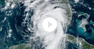
Floridians watched and waited to see how strong Hurricane Idalia will be when it hits land Wednesday morning as a big Category 3 hurricane in the Big Bend, bringing “catastrophic” storm surges all along the Gulf Coast.
The National Hurricane Center said in its 8 p.m. report that hurricane conditions and dangerous storm surges began Tuesday along Florida’s west coast. Forecasters say that Idalia will hit land sometime Wednesday morning, either as early as 5 a.m. or as late as noon.
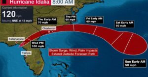
As of 10 p.m., Idalia was 135 miles west-southwest of Tampa, 205 miles south of Tallahassee, and moving north at 18 mph. It had steady winds of up to 110 mph. Forecasters think that the storm waves will be between 10 and 15 feet highest between the Aucilla River, which flows into the Gulf at Apalachee Bay, and Yankeetown.
The National Weather Service said that a tornado watch is in place from Tuesday night until at least 6 a.m. Wednesday. It covers at least 15 counties, from Dixie County to Lee County south of Fort Myers. The National Weather Service Tampa Bay says that more than 7 million people live in the watch area.
In the Big Bend region, between the Aucilla River and Yankeetown, the storm surge could hit 10 to 15 feet, according to the National Hurricane Center. Between 7 and 11 feet could be seen from Yankeetown to Chassahowitzka. There could be 4 to 6 feet in Tampa Bay. As far south as Chokoloskee, the water could rise 3 feet.
Steve Winn, a meteorologist with the National Weather Service, said that wave will start at 3 a.m. Wednesday in the Big Bend area, which is expected to be hit the hardest. Around 2:30 a.m. is when high tide is in that area. He said that when the storm surge started in Tampa Bay, it was low tide at the mouth of the bay.
The National Weather Service in Tallahassee called Idalia “an unprecedented event” because no big storms have ever been recorded going through the bay next to the Big Bend.
The National Weather Service in Tallahassee said, “As far as we know, there have never been any major hurricanes in the Apalachee Bay.” “DO NOT compare this storm to other storms. Nobody has seen this before.”
Late Tuesday afternoon, the predicted path of the storm shrunk and moved a bit west. Because of this, the hurricane watch from Englewood to the middle of Longboat Key ended, and the storm surge watch south of Bonita Beach near Naples also ended.
Seeing a ‘rapid increase’
The most recent forecasts show that Idalia’s steady winds could reach up to 115 mph before it hits land. The storm is moving over water that can get up to 87 degrees.
“Rapid strengthening is likely through landfall, and Idalia is expected to become a very dangerous major hurricane before Wednesday,” the hurricane center said.

As of 8 p.m. Tuesday, Idalia’s hurricane-force winds went out up to 25 miles from its center, and its tropical storm-force winds went out up to 160 miles. Tuesday night, the squalls from Idalia kept going in the Lower Keys and parts of southeast and southwest Florida.
DeSantis increased the number of Florida counties under a state of emergency from 46 on Monday to 49, getting ready for Idalia to hit land. That’s about three-quarters of the state’s counties. Orange, Brevard, and Osceola counties are three of the new counties that are near Orlando. They are inland and on the east coast.
Also, at least 22 counties told people in some low-lying and vulnerable places to leave.
After the storm, more than 30,000 people who work for utilities got together to fix things as quickly as possible.
In a statement released Tuesday night, the governor’s office said that the Florida National Guard is fully active, with 3,700 guardsmen already in place across the state and another 1,800 on their way. This means that a total of 5,500 guardsmen are ready to respond to Idalia before it hits land.
Broward, Palm Beach, and Miami-Dade counties are not part of the state of emergency for Idalia.South Florida will be close to having to issue a heat warning on Wednesday, but it will be a little cooler as Idalia hits land and the “outer spiral” rain bands from the storm reach the area.
The storm center says that after Idalia hits land in the Big Bend area, it will move near or along the coasts of Georgia, North Carolina, and South Carolina late Wednesday or Thursday. Idalia could still be a storm when it moves over southern Georgia and gets close to the coasts of Georgia and South Carolina.
Through Wednesday, tornadoes could also happen in southeast Georgia and along the coasts of the Carolinas.
Both Georgia Gov. Brian Kemp and South Carolina Gov. Henry McMaster declared states of emergency. This freed up state resources and people, including hundreds of National Guard troops.
More News:
- Hurricane Idalia Intensifies: Floridas West Coast Braces for Catastrophic Impact
- Flight Delays And Cancellations: Hundreds of flights are canceled as Hurricane Idalia disrupts air travel
- Hurricane Idalia Tracker: Map and Arrival Times
- Florida braces for major hurricane as Idalia is set for rapid growth
Storm surge and hurricane alerts
The middle of Longboat Key north to Indian Pass, including Tampa Bay, was still under a hurricane alert.
A storm surge warning goes past the cone, all the way south to Englewood and all the way north to Indian Pass.
The storm will bring heavy rain and floods to the west coast and Panhandle of Florida. From Tuesday to Thursday, 4 to 8 inches of rain will fall. Northern Florida could get up to 12 inches of rain.
The governor’s office says that 50 county school districts and nine state colleges have shut down because of the storm.
Several Gulf Coast counties scrapped school on Wednesday, and the University of Florida said it would close its campus and cancel both in-person and online classes on Tuesday and Wednesday. Classes at the University of Central Florida were canceled on Wednesday, and sites at Florida State University in Tallahassee will be closed until Friday, the university said in a post on X, which used to be called Twitter.
On the island of Cedar Key, which is in the middle of the current eye-track cone, Commissioner Sue Colson worked at City Hall with other city officials to pack up papers and electronics. She had a message for the almost 900 people who had to leave the island near the coast of the Big Bend region. More than a dozen state troopers went door-to-door to tell people that the storm surge could reach as high as 15 feet. “One word: Leave,” said Colson. “It’s nothing to talk about.”
Not everyone listened to what was said. The owner of the Island Hotel, Andy Bair, said that he was going to “babysit” his bed-and-breakfast, which was built before the Civil War. Even though Hurricane Hermine flooded the city in 2016, he has owned the building for almost 20 years and it has never flooded.
“I feel like I need to be here because I take care of the oldest building in Cedar Key,” said Bair. “We’ve shown over and over that we won’t disappear. We might feel a little bad for a few days, but we’ll be fine in the end.”
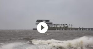
Near Clearwater Beach in Clearwater, Florida, on Tuesday, workers at Toucans Bar and Grill covered the windows in preparation for Hurricane Idalia. People who live along the Gulf Coast of Florida are getting ready for the effects of Idalia. (Photo by Chris O’Meara for AP)
The National Hurricane Center said that there would be between two and five major storms in the Atlantic during the 2023 season.
This year, Idalia is the third storm to hit the Atlantic. Hurricane Franklin, which was near Bermuda on Tuesday, became a Category 4 storm on Monday. It was the first big hurricane of the season in the Atlantic.
Forecasters were also keeping an eye on a possible developing area in the central tropical Atlantic and a tropical wave near the west coast of Africa that was expected to move over the Atlantic in the next couple of days.
As of Tuesday evening at 8 p.m., the system close to Africa had a 60% chance of developing in the next seven days, and the system in the middle area had turned into a tropical depression with sustained winds of 35 mph.
The National storm Center has been saying that the 2023 storm season will be “above normal.” This is because sea surface temperatures are still breaking records, even though El Nio is still trying to cool them down.
Even though the sea surface has been hot for longer than expected, El Nio’s effects, which usually make hurricanes less likely, have come on more slowly.
The National Oceanic and Atmospheric Administration’s National Hurricane Center has predicted 14 to 21 named storms, including 6 to 11 hurricanes and 2 to 5 major hurricanes.
Jose would be the next storm to form.
Foir surther updates, follow us on twitter @UsachargedC