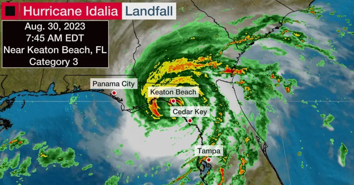
The center of Idalia came ashore near Keaton Beach at 7:45 a.m. EDT with maximum sustained winds of 125 mph, making it a strong Category 3. This preliminarily ties as the strongest hurricane landfall on record in Florida’s Big Bend region.
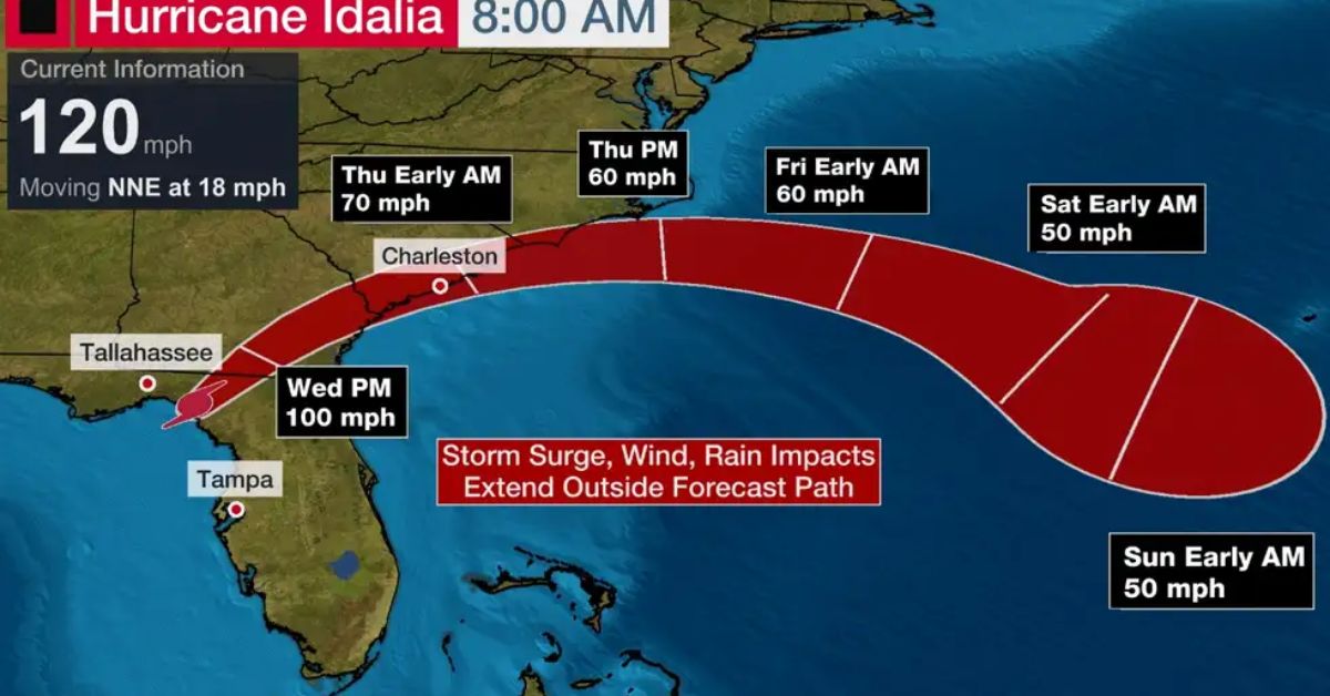
Idalia will now move quickly inland which will bring significant wind and flooding concerns, as well as the threat of tornadoes, into parts of Georgia, as well as South and North Carolina. As a result, hurricane warnings have been posted for portions of the Atlantic Coast.
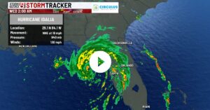
Here’s the latest status on Idalia. The center of Idalia is near the coast of Florida’s Big Bend region and is moving north-northeast at 18 mph.
The hurricane briefly hit Category 4 intensity this morning, but the start of an eyewall replacement cycle reduced maximum sustained winds slightly when the storm made landfall. This does not reduce the severity of the hurricane’s impacts.
Bands of rain containing strong winds continue to swing into much of Florida, and parts of south Georgia.
The highest wind gusts observed so far include 83 mph at Keaton Beach, 81 mph at Horsehoe Point, 70 mph at Sarasota and 58 mph in Tampa and St. Petersburg.
An extreme wind warning has been issued for a part Florida’s Big Bend region until 9:15 a.m. EDT. This rare type of warning indicates the eyewall of a hurricane is coming ashore and is typically reserved for wind speeds of at least 115 mph.
Cedar Key has so far observed a storm surge of 6.2 feet above normal high tide, as of early Wednesday.
Water as far as the eye can see! #Idalia Cedar Key, FL pic.twitter.com/7D6rXfMMax
— Jim Cantore (@JimCantore) August 30, 2023
Storm surge in downtown Tampa reached over 4 feet early Wednesday.
A tornado watch is in effect for parts of Florida and Georgia until 3 p.m. EDT.
Hurricane and tropical storm alerts: A hurricane warning is in effect for the areas shaded in purple in the map below. That includes Gainesville, Tallahassee, Florida, and parts of southern Georgia. A hurricane warning means that hurricane conditions (74+ mph winds) are expected somewhere in this area within 24 hours.
Hurricane watches, tropical storm watches and tropical storm warnings have been issued for many other parts of Florida into south Georgia and the Carolinas, as shown in the map below.
Storm surge is a major danger in Florida: The National Hurricane Center issued this strong wording in its forecast discussion Wednesday morning, “Catastrophic impacts from storm surge inundation of 12 to 16 feet above ground level and destructive waves are expected somewhere between Wakulla-Jefferson County line and Yankeetown, Florida.”
The National Weather Service in Tallahassee noted in their Tuesday morning discussion, “Widespread deep inundation with storm surge flooding will be greatly accentuated by powerful battering waves. Locations may be uninhabitable for an extended period of time. Near-shore escape routes and secondary roads may be washed out or severely flooded.”
A storm surge warning is in effect for Englewood to Indian Pass, including Tampa Bay. This means there is a danger of life-threatening inundation from rising water moving inland from the shoreline within the specified area.
Storm surge watches and warnings are in effect for other parts of the Florida coast to southeast Georgia, South Carolina and North Carolina.
Here are some water levels that could reach 6 feet or higher if the peak surge coincides with high tide. Other peak storm surge forecasts along the coast are shown in the map below:
-Wakulla-Jefferson County line, Florida, to Yankeetown, Florida: 12-16 feet
-Ochlockonee River, Florida, to Wakulla-Jefferson County line, Florida: 8-12 feet
-Yankeetown to Chassahowitzka, Florida: 7-11 feet
-Chassahowitzka, Florida, to Anclote River, Florida: 6-9 feet
-Carrabelle, Florida, to Ochlockonee, Florida: 5-8 feet
-Anclote River, Florida, to middle of Longboat Key, Florida: 4-6 feet
-Tampa Bay: 4-6 feet

Flooding rain is expected in Florida and the Southeast: Heavy rain will continue into Thursday from Florida into parts of Alabama, Georgia and the Carolinas. That will likely trigger local flash flooding in some areas.
Parts of the west coast of Florida, the Florida Panhandle, southeast Georgia and the eastern Carolinas may receive 4 to 8 inches of rainfall, with isolated higher amounts of 12 inches possible, according to the National Hurricane Center.
Damaging winds will reach far from the center: Locations where hurricane warnings are in effect could have numerous power outages and downed trees. Those more numerous outages may extend far inland from northern Florida into southern Georgia.
Elsewhere, at least scattered power outages and some tree damage can be expected from other parts of Florida to the coastal Carolinas.
Hurricane force winds are occurring in the hurricane warned areas of Florida and will extend into southern Georgia later today.
These hurricane force winds will spread into coastal Georgia and South Carolina later Wednesday and Wednesday night, due to how fast the hurricane is moving and its intensity at landfall.
Otherwise, tropical storm conditions are beginning in the warning area along the east coast of Florida and will extend into Georgia, South Carolina and North Carolina later Wednesday into Thursday.
Tornadoes are also a threat. A few tornadoes may develop Wednesday morning across west-central and northern Florida into southeast Georgia.
The threat for a few tornadoes will shift toward the coastal Carolinas Wednesday afternoon and Wednesday night.
Stay tuned to our website Usacharged.com for more updates.